


Stev 2 Le Monastier Landos

rouky
User
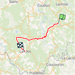

Length
29 km

Max alt
1220 m

Uphill gradient
820 m
Km-Effort
39 km

Min alt
763 m

Downhill gradient
550 m
Boucle
No
Creation date :
2014-12-10 00:00:00.0
Updated on :
2014-12-10 00:00:00.0
8h27
Difficulty : Unknown

FREE GPS app for hiking
 SityTrail
IGN / Geographical institutes
SityTrail Plus
The world is yours!
About
Trail Walking of 29 km to be discovered at Auvergne-Rhône-Alpes, Haute-Loire, Le Monastier-sur-Gazeille. This trail is proposed by rouky.
Description
Départ : Gite du Camping
Arrivée : Gite municipal (Stade)
Positioning
Country:
France
Region :
Auvergne-Rhône-Alpes
Department/Province :
Haute-Loire
Municipality :
Le Monastier-sur-Gazeille
Location:
Unknown
Start:(Dec)
Start:(UTM)
577856 ; 4976308 (31T) N.
Comments